Set, drift and the estimated position
Offshore Theory, written by a superyacht bosun with a commercial Yachtmaster Offshore · 30 October 2026
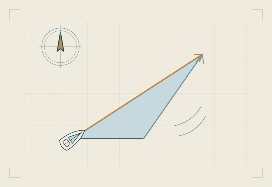
An estimated position is your best answer to "where am I?" when there is nothing in sight to fix by. You start from the last known position, add what the boat did through the water, and then add what the water itself did. That last part is the set and drift of the tidal stream.
The words
- Set: the direction the stream is going towards, in degrees true.
- Rate: its speed, in knots.
- Drift: how far it has carried you in the time you are working, in miles. One hour at 1.5 knots is a drift of 1.5 miles; 40 minutes is 1.0 mile.
- Leeway: the angle between where the boat points and where she goes through the water, because the wind pushes the hull sideways.
The worked example
At 1000 you have a fix, A, and the log reads 23.0. For the next hour you steer 045°T. The wind is north-westerly, on the port beam, and the boat makes about 5° of leeway. At 1100 the log reads 31.0: 8.0 miles through the water. The stream for that hour sets 120°T at 1.5 knots. (Round figures for the guide.)
Step 1: the water track
The wind is from the north-west, so the boat slides south-east, to starboard. Leeway goes downwind: the water track is 045° + 5° = 050°T. From A, lay off 8.0 miles on 050°, with one arrowhead. Without the leeway, that line on 045° would end at the dead reckoning position.
Step 2: the stream
From the end of the water track, lay off one hour of stream: 1.5 miles on 120°, with three arrowheads. Its end is the EP for 1100: mark it with a triangle and the time.
What it gives you
Join A to the EP, with two arrowheads: that is the ground track, the way the boat has really gone. On the example it measures 059°T and 8.6 miles, so for that hour the course over the ground was 059° and the speed over the ground 8.6 knots.
The figures check by components. 8.0 miles on 050° is 6.13 miles east and 5.14 north. 1.5 miles on 120° is 1.30 east and 0.75 south. Together: 7.43 east and 4.39 north, which is 8.6 miles on 059°.
When it is not a whole hour
Use the same time for everything. For a 40-minute run, the water track is the log distance for those 40 minutes, and the drift is two thirds of the hourly rate. If the run crosses from one hour of the stream table into the next, add the two parts of stream one after the other.
EP and course to steer: the triangle the other way up
The EP and the course to steer use the same three vectors, drawn in a different order. For an EP you know the water track and the stream, and the ground track comes out. For a course to steer you know the ground track you want and the stream, and the water track comes out. Leeway also flips: downwind for an EP, into the wind for a course to steer.
The common slips
- Drawing the stream from the start. For an EP it goes on the end of the water track.
- Using the set as where the stream comes from. It is where it goes.
- Using an hour of stream for a 40-minute run. Scale the drift to the time.
- Treating the EP as a fix. It is only as good as the log, the steering, the leeway estimate and the stream figure.
Where this is in the course
Tidal streams and the estimated position →
Leeway: how much, which side, and where it goes →
Free reading notes: tidal streams and the EP →
Questions
What do set and drift mean?
Set is the direction the stream moves the water towards, in degrees true. Drift is how far it moves it in the time you are plotting, in miles. Rate is the same thing per hour, in knots.
In what order do I draw an EP?
From the last position: first the water track, the course steered corrected for leeway, for the distance on the log; then, from its end, the stream for the same time. The end of the stream is the EP.
How do I allow for leeway in an EP?
Downwind. The boat slides away from the wind, so the water track is the heading turned that many degrees away from the wind.
What if I have run for 40 minutes, not an hour?
Use 40 minutes of everything: the log distance for those 40 minutes, and two thirds of the hourly stream rate as the drift.
How is an EP marked on the chart?
With a small triangle and the time beside it. A dead reckoning position is a short line across the track; a fix is a circle.
Related guides
- Tidal diamonds and the tidal stream atlasSet and rate for the hour from a diamond or the atlas, and interpolating between springs and neaps.
- Course to steer and the tidal triangleThe one-hour vector triangle drawn step by step, with leeway, and down to a compass course.
- Dead reckoning vs estimated positionWhat a DR leaves out, what an EP adds, and how each is marked and trusted on the chart.
- The running fixOne mark, two bearings and the run between them: how to transfer the line, with and without a stream.