Planning a passage, step by step
Offshore Theory, written by a superyacht bosun with a commercial Yachtmaster Offshore · 30 October 2026
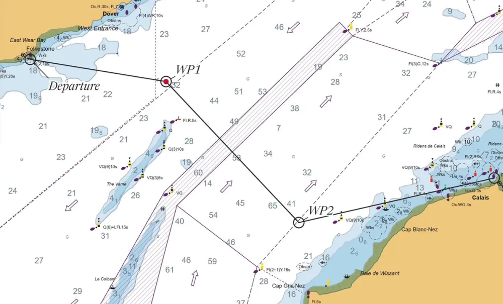
A passage plan answers, before you leave, the questions the passage will ask you at sea: can we go, when do we leave, which way do we go, and what do we do if it goes wrong. Planned in the right order, most of those answers fall out of the tide.
The order that works
- 1. Can it be done? Distance, boat speed, crew, daylight and the forecast. A rough time on passage settles most of this.
- 2. The two ends. The tide at the departure and arrival harbours: enough water to leave, enough to get in, sills, locks and opening times.
- 3. The route. Waypoints in clear water, the tracks and distances between them, the dangers along the way, and any traffic separation scheme.
- 4. The stream. Set and rate along each leg, hour by hour, from the diamonds and the atlas.
- 5. The times. The departure that fits the windows at both ends and uses the stream, with daylight on top.
- 6. The plan on one page. Courses to steer, ETAs, tidal limits, bolt-holes, weather limits and communications.
Step 2 in practice: water to leave
A worked example, with round figures made up for the guide. The departure harbour's entrance dries 0.7 m. The boat draws 1.8 m and the skipper wants 0.5 m under the keel. She needs a height of tide of 0.7 + 1.8 + 0.5 = 3.0 m.
From the tidal curve for the day, the tide reaches 3.0 m at 0610 on the rise and falls below it at 1350. Whatever else the plan says, she leaves between those two times. The arrival harbour has a sill that opens two hours either side of its high water at 1230: she arrives between 1030 and 1430.
Steps 4 and 5: the stream decides the time
The passage is 30 miles at 5.0 knots through the water: six hours with no stream. Along the route the stream is fair at 1.5 knots from 0700 to 1100, then turns foul at 1.0 knot. (To keep the arithmetic visible, the stream here runs along the track; on the chart you would work a course to steer for each leg.)
| Leave at | With the fair stream | Then against it | Arrive |
|---|---|---|---|
| 0700 | 4 hours at 6.5 kn = 26 miles | 4 miles at 4.0 kn = 1 h | 1200 |
| 0800 | 3 hours at 6.5 kn = 19.5 miles | 10.5 miles at 4.0 kn = 2 h 38 min | 1338 |
Leaving at 0700 is inside the departure window, uses all four hours of fair stream, and arrives at 1200, inside the sill's window, 1 hour 38 minutes sooner than leaving at 0800. That is the departure time. If sunrise is at 0630, it is in daylight too.
The route, in more detail
- Waypoints in clear water, at a safe distance off headlands and dangers, and recognisable when you reach them: a buoy, a point off a headland.
- Clearing bearings or depth contours for the dangers near the track, so you can tell at sea that you are clear.
- Traffic separation schemes: if you must cross one, Rule 10(c) asks for a heading as nearly as practicable at right angles to the traffic flow. The stream then carries you along the crossing; that is expected.
- Bolt-holes: where you can stop if you have to, and the tide they need.
On the day
A plan is made to be checked. Before you leave, read the latest forecast against your limits; at sea, compare each fix with the plan and be ready to use the bolt-hole. The plan's job is to have made the decisions in advance, while there was time to think.
Where this is in the course
Module 07 builds whole plans on the real Channel chart, from Dover, Folkestone and Boulogne-sur-Mer, one step per chapter, and then sets a plan as an exam question.
The times: one departure window →
Rule 10, traffic separation schemes, free →
Questions
What should a passage plan include?
The answer to whether the passage can be done; the tide at each end and the times it allows; the route as waypoints with tracks and distances; the dangers and how you stay clear of them; the tidal streams and the course to steer for each leg; the departure time; the weather limits; and where you go if it goes wrong.
What order do I plan in?
Start with whether to go at all, then the ends of the passage, because the tide at each end usually sets the window. Then the route, then the streams along it, and only then the departure time and the courses.
How do I cross a traffic separation scheme?
If you have to cross one, Rule 10(c) of the collision regulations asks you to do so on a heading as nearly as practicable at right angles to the general direction of traffic flow. Plan the crossing leg that way, and let the stream carry you along it.
What is a bolt-hole?
A harbour or anchorage along the route that you can reach if the weather, the crew or the boat makes you stop early. Plan them in advance, with their own tidal limits.
How detailed should a plan be?
Detailed enough that someone else could sail it from the page: tracks, distances, times, tidal limits, the pilotage into each harbour, and the decisions you have already taken about weather and timing.
Related guides
- Clearance under the keel and drying heightsSounding plus height of tide minus draught, drying heights, and the tide you need to cross a bar.
- Tidal diamonds and the tidal stream atlasSet and rate for the hour from a diamond or the atlas, and interpolating between springs and neaps.
- Course to steer and the tidal triangleThe one-hour vector triangle drawn step by step, with leeway, and down to a compass course.
- The shipping forecast and the barometer: go or no-goReading the shipping forecast, the barometric tendency and the sky, and turning them into a decision.